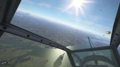
Cold_Gambler Posted July 5, 2006 Report Share Posted July 5, 2006 is the one made with the new technique (from satellite imaging, IIRC) and looks FANTASTIC... check out the textures and the complex shape of the hills: http://www.letka13.sk/forum/viewtopic.php?t=1820&postdays=0&postorder=asc&start=300 The text is all in slovak, but a picture is worth a thousand words. Almost done, says Jurinko. If you haven't seen the screenies before, go to the previous pages for other images (including the "european [ie] farm fields") Amazing what they've done. Can't wait for this one. Quote Link to comment Share on other sites More sharing options...
1. DDz Quorum B16Enk Posted July 5, 2006 1. DDz Quorum Report Share Posted July 5, 2006 Wow!!! Is just me or are those clouds an improvement too, the sky looks so realistic!! Is this part of an upcoming add-on? Quote Link to comment Share on other sites More sharing options...
Cold_Gambler Posted July 5, 2006 Author Report Share Posted July 5, 2006 Yes it will be released with one of the add-ons, but Jurinko didn't say which one. Notice how they managed to place lakes at higher than sea-level altitudes... Hmm... "Break Mussolini out of Prison with a Rufe" mission Quote Link to comment Share on other sites More sharing options...


Recommended Posts
Join the conversation
You can post now and register later. If you have an account, sign in now to post with your account.